Yes, Route 66 is safe for tourists, including older drivers and people traveling alone. Most of its 2,448 miles are ordinary paved roads through towns, farm country and the edges of cities, and the dangers that do exist are predictable: a few rough or closed segments, long desert gaps with no fuel or cell signal, summer heat, winter snow in the mountains, animals on the road at dusk, and the usual car break-ins in big cities. Plan for those six things and Route 66 is no riskier than any other long American road trip.
I'm Helena. I drove the whole road from Chicago to Santa Monica in April 2026 for the Field Manual, and I get this question more than any other, usually from readers in their sixties and seventies or from people planning to go solo. Here is the honest version, with the official sources behind it.
Is Route 66 dangerous?
Not in the way people fear. There is no single stretch you have to drive. The old road runs beside an interstate (I-55, I-44 or I-40) for most of its length, so a fast, modern highway with services is usually a few minutes away. If a segment looks rough, closed or simply too much, you get on the interstate and rejoin the old road at the next exit. I explain how the two roads fit together in Route 66 vs I-40.
When people get into trouble, it is almost always one of these:
- Running low on fuel or water on a desert stretch in Arizona or California.
- Driving a mountain or gravel segment in the dark, in rain, or in a vehicle that is too big for it.
- Crossing the Mojave in the afternoon in July or August.
- Hitting a deer, an elk or a cow at dusk on a rural road.
- Leaving luggage visible in a parked car in a big city.
Every one of those can be planned away. Here is how.
Which parts of Route 66 are rough, unpaved or closed?
The old road is paved almost everywhere you will want to drive it. A handful of segments are narrow, steep, gravel, or closed for bridge work, and these are the ones to decide on in advance.
| Segment | State | What it's like | My advice |
|---|---|---|---|
| Oatman Road over Sitgreaves Pass | Arizona | Paved, narrow, hairpin curves and steep grades up to 3,586 feet | Drive it in daylight and good weather. No vehicles over 40 feet. |
| Glenrio to San Jon | Texas/New Mexico | 17 miles of gravel, a bridge condemned after a May 2023 flood, a dirt path through the creek bed | Take I-40 in a rental, an RV or after rain. |
| National Trails Highway east of Amboy | California | Sections closed for bridge replacement; work zones near Amboy into 2027 | Check the county's closure page the week you go. |
| The Ribbon Road near Miami | Oklahoma | A nine-foot-wide original paving | Fine in a car at low speed; not for an RV. |
The Oatman Highway: steep, narrow, and worth it in daylight
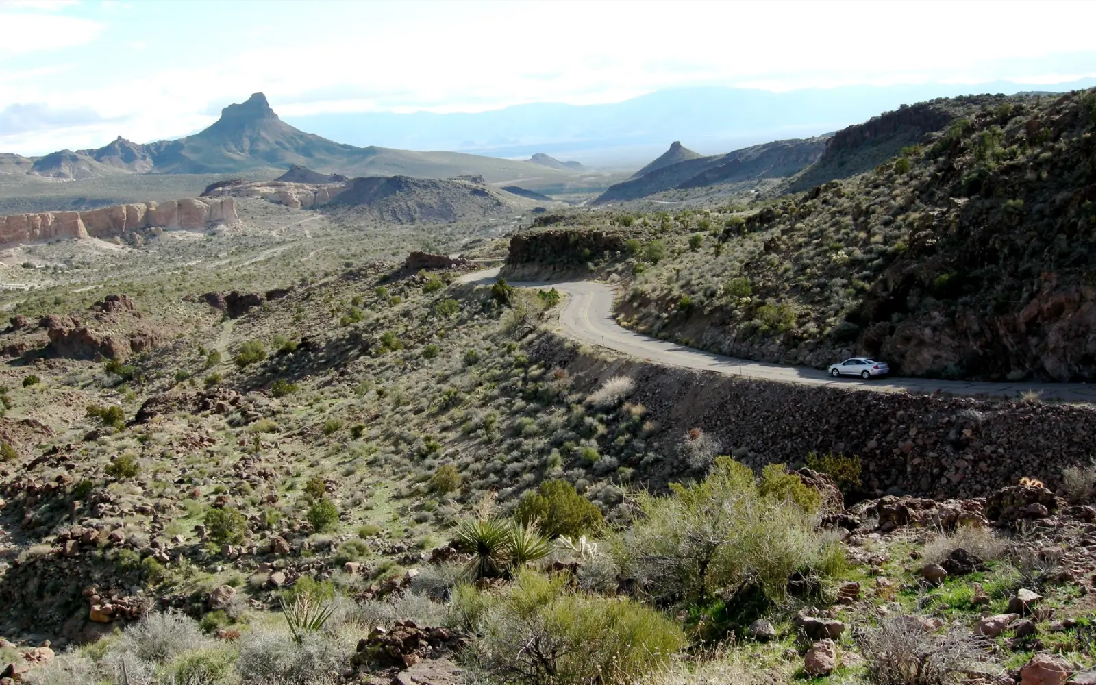
West of Kingman, the old road becomes what the Bureau of Land Management calls the Route 66 Oatman Road Back Country Byway, 42 miles of two-lane blacktop. It climbs through the Black Mountains to Sitgreaves Pass at 3,586 feet, then drops to the old mining town of Oatman with hairpin curves and steep grades on both sides. In places there is no shoulder and no guardrail, just a drop to the desert floor.
It is paved and open, and ordinary drivers in ordinary cars do it every day. But it is the one road on Route 66 I would not drive tired, in the dark, in heavy rain or in a big rig. The BLM says vehicles over 40 feet are not allowed over the pass between Golden Valley and Oatman, and it recommends visiting from October through April, when the desert is cooler. If curves and drop-offs make you anxious, take I-40 from Kingman toward Topock and drive up to Oatman from the west side. My Arizona stops guide covers the whole stretch.
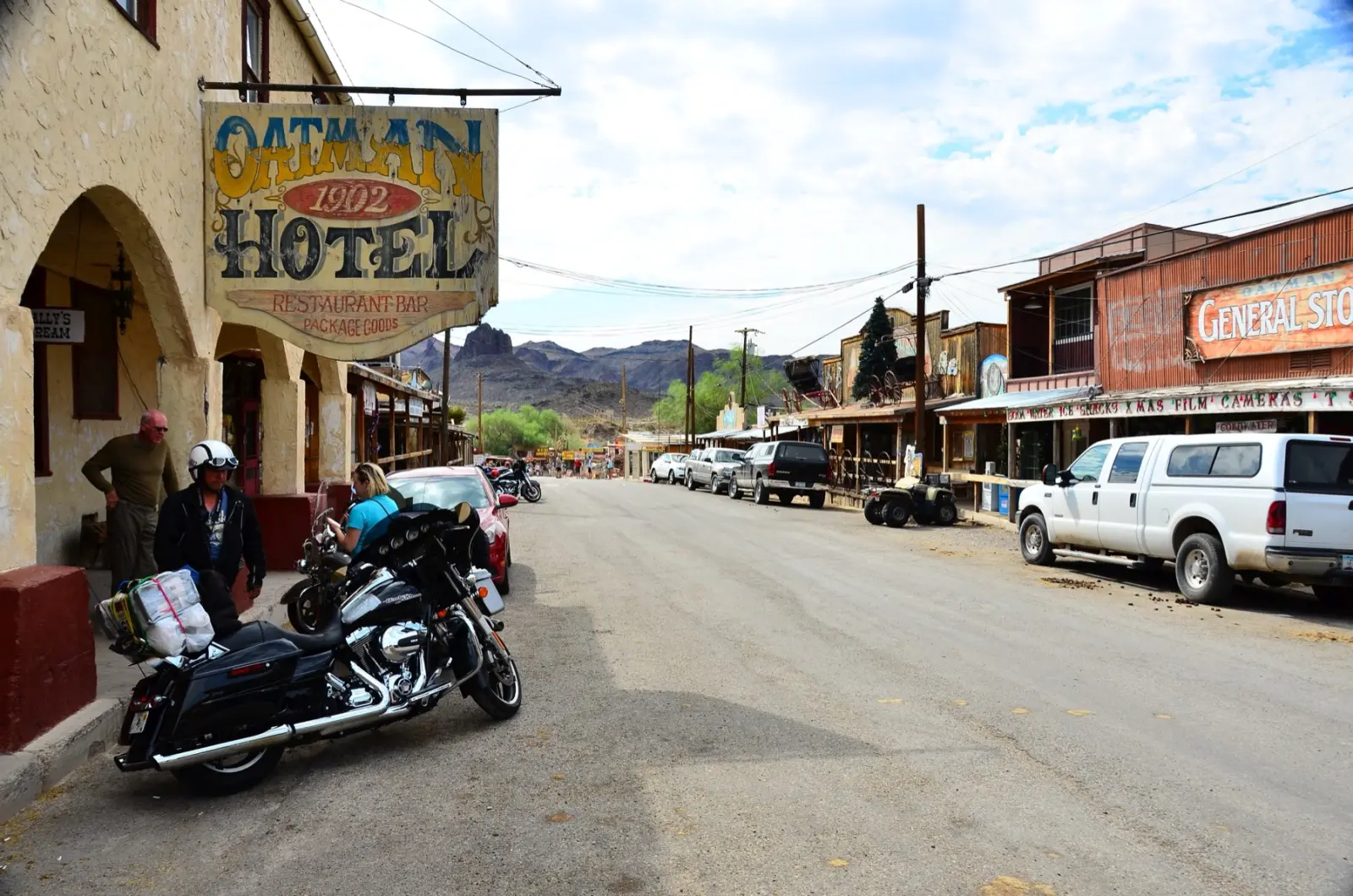
In Oatman itself, the hazard is slow and furry. Wild burros from the BLM's Black Mountain herd wander the main street and walk right up to cars. Drive at walking pace through town, give them room, and feed them only the hay cubes sold in the shops, never in the roadway. Mohave County has put up signs saying exactly that.
Glenrio to San Jon: gravel and a broken bridge
Where Route 66 crosses from Texas into New Mexico, the original alignment is 17 miles of gravel through the ghost towns of Endee and Bard. A flood in May 2023 left the old timber bridge on that stretch condemned for vehicles, and the county cut a gravel path through the creek bed. Route 66 News reported that compact cars can manage it in dry weather, but large RVs and trucks probably shouldn't try, and nobody should try it after rain. Most rental agreements also forbid unpaved roads. I'd take I-40 for those miles; you lose very little. More in my New Mexico guide.
The Mojave: closed bridges and work zones
In California, the old road across the desert is called the National Trails Highway, and it has spent years being rebuilt. As San Bernardino County described it at the end of June 2026, Barstow to Ludlow to Amboy was open, Amboy to Kelbaker Road was open, and Goffs Road and Essex Road between I-40 and the old road were closed to through traffic. In September 2025 the county awarded a $24.1 million contract to replace ten 1930s timber bridges near Amboy, with work expected to run into spring 2027, and storms in January 2026 forced emergency repairs to more bridges between Lavic and Amboy. None of that makes the road unsafe, but it means you should check the county's road closures page the week you go and never drive around a closure sign. My California stops guide has the route I'd use today.
How long are the empty stretches with no gas or cell signal?
East of Albuquerque you are rarely far from a town. West of it, the gaps get long, and they are the real reason to plan. These are approximate distances between reliable fuel towns, measured on a map; your exact numbers depend on which alignment you take.
| Stretch | Approx. miles | Fill up in | Notes |
|---|---|---|---|
| Santa Rosa to Moriarty, NM (1937 route) | 115 | Santa Rosa | Open high plains, often windy |
| Gallup, NM to Holbrook, AZ | 96 | Gallup | Sparse services; fill up before the Petrified Forest |
| Seligman to Kingman, AZ | 89 | Seligman | Small towns only in between |
| Kingman to Topock, AZ, via Oatman | 54 | Kingman | Don't count on fuel at Cool Springs or Oatman |
| Needles to Amboy, CA, via I-40 and Kelbaker Road | about 90 | Needles | The longest gap on the route; no gas where Kelbaker Road meets I-40 |
The National Park Service warns that there is no gas station where Kelbaker Road meets I-40, and that cell service is unreliable or nonexistent across most of the Mojave National Preserve. The BLM says the same about the Mojave Trails National Monument, which the old road runs through: phones do not get a signal everywhere. Roy's in Amboy was selling gas in mid-2026, but a single small station in the middle of the desert is a backup, not a plan.
My rules for the western half:
- Fill up at half a tank in every real town west of Albuquerque.
- Download offline maps for the whole route before you leave, and carry a paper map as well.
- Carry at least one gallon of water per person per day, which is the minimum both the NPS and the BLM recommend for the Mojave, plus extra for the car.
- Tell someone your route and your expected arrival time each morning, and check in when you arrive.
- If the car breaks down in the desert, stay with it. It's shade, and it's far easier to spot than a person.
To see how many miles and hours separate the towns on your own plan, the free trip planner at route66operator.com calculates them between 56 towns on the route.
Is Route 66 dangerous in summer heat or winter weather?
Weather is the biggest variable, and the two ends of the road peak in opposite seasons.
Desert heat
Needles, California, is the hottest stop on the route. NOAA's 1991 to 2020 normals put its average high at 106°F in June and 111°F in July, with a July low of 87°F, which means the desert barely cools off at night. In summer, cross the Mojave at first light, be off the old road by early afternoon, and never let the fuel gauge or the water supply run low. Heat is also hard on engines and tires, so check both before the desert days.
From early July, the Arizona monsoon brings afternoon thunderstorms, according to the National Weather Service in Flagstaff, and with them flash floods and dust. Never drive into a flooded dip or wash; the water is often deeper and faster than it looks.
Snow, wind and storms
The stretch from Gallup through Flagstaff to Williams sits high, around 7,000 feet at Flagstaff, and gets real winter. Flagstaff averages 18.5 inches of snow in December and 20.9 in January. In spring, Oklahoma is in tornado season, with May the busiest month, and the eastern plains of New Mexico get strong winds that can raise enough dust to make driving hazardous, according to the National Weather Service in Albuquerque. Check the forecast every morning and keep a spare day so a storm never forces you to drive.
The easiest way to dodge most of this is timing. May and mid-September through October are the safest and most comfortable months for the whole road; I go month by month in the best time to drive Route 66.
Is Route 66 dangerous at night?
Night is when I'd be most careful, and it is the one rule I'd give every reader: plan your days so you arrive before dark. In a federal analysis of crash data, NHTSA found that about half of passenger vehicle occupant deaths happened at night, even though only about a quarter of driving does, which makes the fatality rate per mile roughly three times higher after dark.
Much of the old road is unlit two-lane without shoulders, the Oatman curves and the Glenrio gravel are no places to find in the dark, and dusk is exactly when animals move.
Wildlife and livestock
The Federal Highway Administration estimates one to two million collisions between cars and large animals every year in the United States, causing about 26,000 injuries and 200 deaths. On Route 66 that means deer in Illinois, Missouri and Oklahoma, elk and deer around Flagstaff and Williams, and, in parts of New Mexico and Arizona, cattle on unfenced range. When you cross a cattle guard or see an open range sign, slow down. If an animal appears, brake firmly in a straight line rather than swerving; a swerve on a narrow road is often worse than the hit.
Are there places on Route 66 where you should be careful?
Route 66 starts in one big city, ends in another, and passes through St. Louis, Tulsa, Oklahoma City, Amarillo and Albuquerque. For a traveler the risk in any of them is mostly property crime, not violence. I won't name neighborhoods: crime maps change, and a list would be unfair to the people who live there.
What the data does say is where car crime concentrates. The National Insurance Crime Bureau's report on 2025 vehicle thefts put the Los Angeles metro area first in the country by total thefts, Chicago third and the Riverside-San Bernardino area ninth. Those are the two ends of Route 66. The same report found that thefts fell 23% in 2025 after a 17% drop in 2024, so it is getting better, not worse.
Practical rules for the cities:
- Never leave luggage, bags, cameras or shopping visible in a parked car, even for ten minutes at a photo stop.
- Unload the car when you check in, and park in a lit spot near the office or under a camera.
- At the famous end-of-road spots like the Santa Monica Pier and downtown Chicago, use a paid garage or lot rather than the street.
How do I choose a safe motel on Route 66?
Old does not mean unsafe, and most restored motor courts are run by owners who care about their guests. But quality varies more than at interstate chains, so I check three things:
- Recent reviews. Read the last few months, not the average. Look for mentions of cleanliness, locks and the owner being on site.
- The door and the parking. Most classic motels have doors that open straight onto the parking lot, which is convenient for luggage. Make sure the door has a deadbolt and the lot is lit.
- Booking ahead. Arriving at dusk without a room is how people end up driving on at night or taking whatever is left. Book the famous motels well ahead.
My picks, by state and budget, are in the best Route 66 motels, and the Route 66, The Definitive Field Manual lists 9 hotels and 9 restaurants per state on three budgets, all researched on the road in April 2026.
Is Route 66 safe for elderly travelers?
Yes. Older drivers are a large share of the people on the road, and the pace of Route 66 suits them: short days, frequent stops, and towns every few miles for most of the way. The adjustments I'd make are about stamina, heat and medical access, not about whether you can do it.
Driving days
- Keep driving days short and plan to arrive mid-afternoon. A two-week trip gives you room for that; my Route 66 road trip planner shows how to split the road.
- Stop every couple of hours to stretch and drink water, whether you feel thirsty or not.
Medicine and health
- Bring more of every prescription than the trip needs, in your carry-on or day bag, with a written list of medications and doses.
- Some medicines change how your body handles heat. Ask your doctor before a summer trip through the desert.
- Keep medicines out of a hot parked car; a cooler bag helps.
Medical access and insurance
Through Illinois, Missouri and Oklahoma you are rarely far from a sizable town. In the West the gaps are longer, and the larger towns, like Albuquerque, Flagstaff, Kingman and Barstow, are where the full hospitals are. If you have a condition that could flare up, look up the hospitals along your route before you leave and save them in your offline map.
If you're on Medicare, Original Medicare works the same in every state. If you have a Medicare Advantage plan, AARP notes that plans must cover emergency and urgent care anywhere in the United States, even outside their network; routine visits may not be covered away from home. Call your plan before the trip and ask exactly what applies.
Is it safe to drive Route 66 alone?
Yes, and many people do it solo, including women traveling on their own. The road is busy with fellow travelers, the towns are used to visitors, and motel owners tend to look out for the people staying with them. The risks are the same as for everyone; you just have no one to share the driving or to go for help, so the routines matter more.
- Daily check-ins. Send your route and expected arrival time to someone each morning, and a message when you arrive. Share your live location with one trusted person.
- Daylight only. Solo travelers should treat arriving before dark as a firm rule.
- Roadside assistance. Have a membership or the rental company's number saved, and know that in the desert it may take a long time to arrive.
- A charged phone. Bring a car charger and a power bank. Remember that in parts of the Mojave and western Arizona there may be no signal at all, which is why the check-ins matter.
Riding a motorcycle alone is a different calculation; I cover fuel range and the roads to avoid in the Route 66 motorcycle trip planner.
Route 66 safety checklist
| Item | Why | When |
|---|---|---|
| Check closures (San Bernardino County, Route 66 News) | Mojave bridges and gravel segments change after storms | The week before, and again on the day |
| Offline maps and a paper map | No signal in parts of the Mojave and western Arizona | Before you leave home |
| One gallon of water per person per day, plus extra | The NPS and BLM minimum for the desert | From Albuquerque west |
| Fill up at half a tank | Gaps of 90 to 115 miles between reliable fuel | Every town west of Albuquerque |
| Tires, coolant and spare checked | Heat and rough pavement are hard on cars | Before the desert days |
| Arrive before dark | Night crashes, animals, unlit two-lane roads | Every day |
| Route and arrival time shared | Someone knows where to look | Every morning |
| Prescriptions, medication list, insurance card | Medical access is thinner in the West | Pack before you leave |
| Nothing visible in the parked car | Car break-ins in the big metros | Every stop |
| A spare day in the plan | So weather never forces you to drive | When you plan the trip |
The short version
Route 66 is safe for tourists, for older travelers and for people driving alone. Drive in daylight, fill up and carry water from Albuquerque west, skip the gravel and the mountain pass if they are not for you, check the Mojave closures before you go, and keep your car empty of anything worth stealing. Do those things and the road is what it has always been: slow, friendly, and full of people glad to see you.